Tell

Updating the inbuilt Mib2 Satnav / Mib2 tricks and Mib1

ackaz

Active Member
Apr 15, 2021
16
14
Cardiff
I just tried updating my maps on my 2018 Cupra 300 w/ Virtual Cockpit.

I followed the steps to update maps, backed up the original SD Card, replaced the new OVERALL.NDS with my backed up one and then when I put it back in the slot, it comes up with the "Navigation database not available", and an ERROR SD CARD 1 comes up too.

I then tried to put my old backed up files back on the SD card and it's now come up with the same "Navigation database not available." Any ideas? The SD Card is FAT32 and official SEAT as you can see by the photo.
D398B80B-CC46-4332-AE74-642F03512F33.jpeg
image.jpg
75F6E1EA-3D47-47E5-87D9-A605FA305614.jpeg


Previously my system info screen before trying to update, looked like this:
1642017378201.png
 

t_v

Active Member
Feb 19, 2021
101
78
I just tried updating my maps on my 2018 Cupra 300 w/ Virtual Cockpit.

I followed the steps to update maps, backed up the original SD Card, replaced the new OVERALL.NDS with my backed up one and then when I put it back in the slot, it comes up with the "Navigation database not available", and an ERROR SD CARD 1 comes up too.

I then tried to put my old backed up files back on the SD card and it's now come up with the same "Navigation database not available." Any ideas? The SD Card is FAT32 and official SEAT as you can see by the photo.
View attachment 29294 View attachment 29295 View attachment 29296

Previously my system info screen before trying to update, looked like this:
View attachment 29297
If it doesn't work out I have my V7 card upgraded to the most recent version for sale: https://www.facebook.com/marketplace/item/262802419127212
 

Tell

Full Member
Staff member
Moderator
I just tried updating my maps on my 2018 Cupra 300 w/ Virtual Cockpit.

I followed the steps to update maps, backed up the original SD Card, replaced the new OVERALL.NDS with my backed up one and then when I put it back in the slot, it comes up with the "Navigation database not available", and an ERROR SD CARD 1 comes up too.

I then tried to put my old backed up files back on the SD card and it's now come up with the same "Navigation database not available." Any ideas? The SD Card is FAT32 and official SEAT as you can see by the photo.
View attachment 29294 View attachment 29295 View attachment 29296

Previously my system info screen before trying to update, looked like this:
View attachment 29297
Was a Mac OS software involved in this ?. If so try CleanMydrive running it on the SD card. Mac's put dross on data downloaded which needs to be removed.

Failing that is the backup placed back in the root of the SD card. Not one down.

The other one on recent cards people have reformatted the cards rather than just doing a simple delete. Recent cards don't take too kindly to this.

Failing all of this a long hold on the on button till it reboots.
 

Tell

Full Member
Staff member
Moderator
If it doesn't work out I have my V7 card upgraded to the most recent version for sale: https://www.facebook.com/marketplace/item/262802419127212
V7 wont work with V6 unless the card is corrupted then it's just the CID.

Don't reckon earlier cards were effected by the format issue only recent ones but thru that in for good measure.

Suspect it's just an operator error... or use of a Mac without CleanMydrive.
 

ackaz

Active Member
Apr 15, 2021
16
14
Cardiff
Was a Mac OS software involved in this ?. If so try CleanMydrive running it on the SD card. Mac's put dross on data downloaded which needs to be removed.

Failing that is the backup placed back in the root of the SD card. Not one down.

The other one on recent cards people have reformatted the cards rather than just doing a simple delete. Recent cards don't take too kindly to this.

Failing all of this a long hold on the on button till it reboots.
I used a Windows 11 device, formatted to FAT32, put the latest 6P0 map update onto the card, directly so as soon as you open the card it has the "maps" folder on it. Replaced OVERALL.nds.

Strange that my backup/original files aren't working either..
1642018652513.png


Have tried restarting the unit multiple times to no avail, also tried driving around to see if it would pick anything up magically but no luck.
 
Last edited:

Tell

Full Member
Staff member
Moderator
I used a Windows 11 device, formatted to FAT32, put the latest 6P0 map update onto the card, directly so as soon as you open the card it has the "maps" folder on it. Replaced OVERALL.nds.

Strange that my backup/original files aren't working either..
View attachment 29298

Have tried restarting the unit multiple times to no avail, also tried driving around to see if it would pick anything up magically but no luck.
Driving around won't sort it out. It will be the format I guess. The sector size has to be correct. People have tried to reduce the sector size then physically screwed up the card which can't be retrieved. People say you should do that incorrectly now it runs the risk of messing up the card. It has to be Fat32 in anycase since the operating system in the units only reads that. In case Windows 11 is non standard you could try this one:


I'll post up an image of where the map sits in the directory in case you got it wrong below here and the byte size in a minute. Failing that it's buying a VAG card and putting your original back on it if you have succeeded in messing up the SD card in the format. Then you can do the workaround. You delete what's on it, not format.
 
  • Like
Reactions: ackaz

ackaz

Active Member
Apr 15, 2021
16
14
Cardiff
Driving around won't sort it out. It will be the format I guess. The sector size has to be correct. People have tried to reduce the sector size then physically screwed up the card which can't be retrieved. People say you should do that incorrectly now it runs the risk of messing up the card. It has to be Fat32 in anycase since the operating system in the units only reads that. In case Windows 11 is non standard you could try this one:


I'll post up an image of where the map sits in the directory in case you got it wrong below here and the byte size in a minute. Failing that it's buying a VAG card and putting your original back on it if you have succeeded in messing up the SD card in the format. Then you can do the workaround. You delete what's on it, not format.
Yeah must have mucked it up during the formatting some how. Could I just buy the latest V15 off ebay and probs use that? They say it fits my car unless it's gonna cause a CID issue?
 

Tell

Full Member
Staff member
Moderator
Yeah must have mucked it up during the formatting some how. Could I just buy the latest V15 off ebay and probs use that? They say it fits my car unless it's gonna cause a CID issue?
The CID is a common VAG CID which it will read OK, but the unit is matched up to the overall.nds common release of your card version so you will need that to make it work. Choose a 32gb VAG card if you fancy driving from one side to another of Europe or a 16gb with one of the zoned releases.

Anyhow, it should look like this on your card where my D is your card, directory MAP (ignore USB, have to use a USB / SD adaptor in the laptop):

1642025741930.png


If you had reformatted it... I see Windows 11 defaults to 32 kilo bytes try 4096 bytes as per this thread, that's the number I remember, Windows 11 may be defaulting it above what it originally was:


Windows 11 may default it outside of the devices ability to read it or corrupt it if the SD card is built for the cluster size not to be changed (reported there are VAG cards around where you can't change the cluster size without damaging them... I have a link to that somewhere), but worth a try to get the cluster size to 4096 if it isn't at the minute. Failing all of that buy another card since the format will have messed up the card.

Windows 11 default... which may be problematic... make the allocation unit size 4096 bytes not what it shows just in case it's this.
1642025894563.png
 
Last edited:
  • Like
Reactions: ackaz

ackaz

Active Member
Apr 15, 2021
16
14
Cardiff
The CID is a common VAG CID which it will read OK, but the unit is matched up to the overall.nds common release of your card version so you will need that to make it work. Choose a 32gb VAG card if you fancy driving from one side to another of Europe or a 16gb with one of the zoned releases.

Anyhow, it should look like this on your card where my D is your card, directory MAP (ignore USB, have to use a USB / SD adaptor in the laptop):

View attachment 29303


If you had reformatted it... I see Windows 11 defaulst to 32 kilo bytes try 4096 bytes as per this thread, that's the number I remember, Windows 11 may be defaulting it above what it originally was:


Windows 11 may default it outside of the devices ability to read it or corrupt it if the SD card is built for the cluster size not to be changed (reported there are VAG cards around where you can't change the cluster size without damaging them... I have a link to that somewhere), but worth a try to get the cluster size to 4096 if it isn't at the minute. Failing all of that buy another card since the format will have messed up the card.

Windows 11 default... which may be problematic... make the allocation unit size 4096 bytes not what it shows just in case it's this.
View attachment 29304
Thank you for all this info. Will give 4096 a go. If it doesn't work I'll just get a new VAG card :). Will let you know how I get on.
 

Tell

Full Member
Staff member
Moderator
Thank you for all this info. Will give 4096 a go. If it doesn't work I'll just get a new VAG card :). Will let you know how I get on.
If that doesn't work of getting it back to how it was try this. 4096 is indeed the correct cluster size... try this:


The overall.nds from 1030.

There was one release where Seat messed up Mapcare by taking it off which then subsequently hit updates with Mapcare. You might have hit that one. It activates a function but by rolling back a little before using the overall.nds file to go forward fixes it. It hadn't come up on the thread before till that post and I did read a mention on a Spanish forum of the one year release which messed up the workaround. If it's that, 1030 overall.nds will fix that. That's if 1030 is before what you were on ?. You can never use an overall.nds file after the release you were on, but the bad release messed up using that one going forward, so you went back a bit. That was the guys solution in the link above.

If you were on a release prior to 1030 that won't help. The other thing is the lost and found link to year dot of Seats. That's if the unit has instigated something weird and it's not the format issue. The solution I originally offered Greg above but was found not to work but 1030 did for him.

You'd do something more than a Quick format, uncheck to full format, fat32 4096 byte cluster size but as said Formatting these cards isn't recommended now since it can brick them. But since you have done it once and damage will have been done. Just a simple delete is the way ahead.
 
  • Like
Reactions: ackaz
Jan 17, 2022
6
1
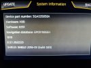
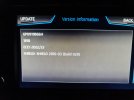
Hi I'm a new member I just picked up my 17 plate ateca on friday and noticed the satnav was outdated. I've searched the forums as suggested by the dealer I bought from and came across a few forums all following a similar method. I've tried following these without any luck I've tried the seat maps and also tried Europe 1 and 2 from the vw site copying my original Overall.nds file into the new map update and I'm coming up with the message in below photo. I'm not sure what's going wrong but it looks like a previous owner has updated at some point as info is missing which I've now replaced in part 4 by following this thread. I'll include some photos of my info from car in case it helps.

Thanks
Carl
20220115_165924.jpg
20220115_170043.jpg
20220116_170018.jpg
20220116_170025.jpg
20220117_083521.jpg
20220117_083610.jpg
20220117_091008.jpg
20220117_104553.jpg
20220117_104609.jpg
 
Jan 17, 2022
6
1
Never mind I've managed to get it working using the lost/stolen card work around mentioned in overview. Thank you
 

ackaz

Active Member
Apr 15, 2021
16
14
Cardiff
If that doesn't work of getting it back to how it was try this. 4096 is indeed the correct cluster size... try this:


The overall.nds from 1030.

There was one release where Seat messed up Mapcare by taking it off which then subsequently hit updates with Mapcare. You might have hit that one. It activates a function but by rolling back a little before using the overall.nds file to go forward fixes it. It hadn't come up on the thread before till that post and I did read a mention on a Spanish forum of the one year release which messed up the workaround. If it's that, 1030 overall.nds will fix that. That's if 1030 is before what you were on ?. You can never use an overall.nds file after the release you were on, but the bad release messed up using that one going forward, so you went back a bit. That was the guys solution in the link above.

If you were on a release prior to 1030 that won't help. The other thing is the lost and found link to year dot of Seats. That's if the unit has instigated something weird and it's not the format issue. The solution I originally offered Greg above but was found not to work but 1030 did for him.

You'd do something more than a Quick format, uncheck to full format, fat32 4096 byte cluster size but as said Formatting these cards isn't recommended now since it can brick them. But since you have done it once and damage will have been done. Just a simple delete is the way ahead.
Ended up buying a V15 off eBay and it works perfectly without needing to replace the OVERALL.NDS file. I think the format just screwed up my original card completely. Thanks for your help and info, will use it going forward.
 
  • Like
Reactions: Tell

Tell

Full Member
Staff member
Moderator
Hi I'm a new member I just picked up my 17 plate ateca on friday and noticed the satnav was outdated. I've searched the forums as suggested by the dealer I bought from and came across a few forums all following a similar method. I've tried following these without any luck I've tried the seat maps and also tried Europe 1 and 2 from the vw site copying my original Overall.nds file into the new map update and I'm coming up with the message in below photo. I'm not sure what's going wrong but it looks like a previous owner has updated at some point as info is missing which I've now replaced in part 4 by following this thread. I'll include some photos of my info from car in case it helps.

Thanks
Carl View attachment 29380 View attachment 29381 View attachment 29382 View attachment 29383 View attachment 29384 View attachment 29385 View attachment 29386 View attachment 29387 View attachment 29388
Problem with the second hand cars is you dont know what the previous owner has been up to with it and whether you have been given the original card it's paired with. The pairing is related to the release that's first put in the unit. Saying that you can use any previous release of the overall.nds file to make it work.

To me the card looks a little early for a 2017 release car. After taking a copy of everything so that nothing is lost suggest you go for the most up-to-date maps 1810, that's the November 2021 release linked in the resource section:


Then I'd follow the Lost, Stolen and Missing Cards from a Mib2 Standard Unit section to pick up the V1 overall.nds file.

Then follow the workaround section as documented in the resource linked above. Taking special attention if you are using the Mac OS.

PS as per above you delete what is on the card don't attempt to reformat, note above.
 
  • Like
Reactions: CarlB1981
Jan 17, 2022
6
1
Problem with the second hand cars is you dont know what the previous owner has been up to with it and whether you have been given the original card it's paired with. The pairing is related to the release that's first put in the unit. Saying that you can use any previous release of the overall.nds file to make it work.

To me the card looks a little early for a 2017 release card. After taking a copy of everything so that nothing is lost suggest you go for the most up-to-date maps 1810, that's the November 2021 release linked in the resource section:


Then I'd follow the Lost, Stolen and Missing Cards from a Mib2 Standard Unit section to pick up the V1 overall.nds file.

Then follow the workaround section as documented in the resource linked above. Taking special attention if you are using the Mac OS.

PS as per above you delete what is on the card don't attempt to reformat, note above.
Thank you I managed to sort it using your very detailed guide with the V1 overall.nds file. Tried it with the seat maps 1st so backed that back up and currently waiting on the vw ones transferring over to try.
 
  • Like
Reactions: Tell
Jan 17, 2022
6
1
Thank you I managed to sort it using your very detailed guide with the V1 overall.nds file. Tried it with the seat maps 1st so backed that back up and currently waiting on the vw ones transferring over to try.
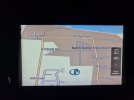
VW ones work now too over the moon, it's been doing my head in. At least half my housing estate shows now so will have to update again at some point when they are released. 20220117_173704.jpg 20220117_173205.jpg 20220117_173144.jpg
 

Tell

Full Member
Staff member
Moderator
VW ones work now too over the moon, it's been doing my head in. At least half my housing estate shows now so will have to update again at some point when they are released. View attachment 29397 View attachment 29398 View attachment 29399
You can always put your submission in to TomTom on Mapshare on the link with the street names etc and telling them new houses are built. I've had quite a few put in that. They tell you whether they agree with you or not. Speed limit ones they are fussy about since that's less easy to check. They need to check the local authority planning maps. LAs issue the street names and the house numbers that's on those map. They go off to the post office for postcodes and then get drawn into the official OS planning maps. ONS do their bit on the postcode directory etc.

Looking at the planning map (which isnt the one attached... keep this source to myself) the map looks pretty up-to-date based on the copyright date. Still to be drawn in and processed. Give it another year. Northumberland Council are a bit mean their report a pot hole map shows 2013 planning maps.... A bit tight. Some are like this don't put up on their websites the latest OS planning maps. So if you saw it in there you say, go and see to TomTom. The existence of the postcode means its been house numbered so the developers map is the other evidence put against the postcode directory with the house numbers.

You can always try to fast track it by taking a picture of the developers plan, web link. Do your own site survey with photography of street junctions with names, with GPS coordinates on the image and upload to TomTom Mapsgare site. They might take that.

Screenshot_20220117-184810.png
 
  • Like
Reactions: CarlB1981
Jan 17, 2022
6
1
You can always put your submission in to TomTom on Mapshare on the link with the street names etc and telling them new houses are built. I've had quite a few put in that. They tell you whether they agree with you or not. Speed limit ones they are fussy about since that's less easy to check. They need to check the local authority planning maps. LAs issue the street names and the house numbers that's on those map. They go off to the post office for postcodes and then get drawn into the official OS planning maps. ONS do their bit on the postcode directory etc.

Looking at the planning map (which isnt the one attached... keep this source to myself) the map looks pretty up-to-date based on the copyright date. Still to be drawn in and processed. Give it another year. Northumberland Council are a bit mean their report a pot hole map shows 2013 planning maps.... A bit tight. Some are like this don't put up on their websites the latest OS planning maps. So if you saw it in there you say, go and see to TomTom. The existence of the postcode means its been house numbered so the developers map is the other evidence put against the postcode directory with the house numbers.

You can always try to fast track it by taking a picture of the developers plan, web link. Do your own site survey with photography of street junctions with names, with GPS coordinates on the image and upload to TomTom Mapsgare site. They might take that.

View attachment 29401
Yeah its been a pain sorting everything out especially with the address not showing up on half the things I need changed, especially the DVLA. Google maps has the street updated already after I submitted the street name and postcode, I'll have a look at doing some of the ones you've mentioned too.
 

Tell

Full Member
Staff member
Moderator
Yeah its been a pain sorting everything out especially with the address not showing up on half the things I need changed, especially the DVLA. Google maps has the street updated already after I submitted the street name and postcode, I'll have a look at doing some of the ones you've mentioned too.
You will get an accepted marker on TomTom if they get accepted then you just have to wait till they filler thru into the VAG standard mib2. Making a start early has benefits. I see they have the roads in, in Here Maps but not the names, mib2 high and mib3.

When I say roads often on aerial images of estates being built you see the builders roads which aren't the final roads. Closes appear as Crescents. If you don't know the area only the planning maps and developer's maps show the actual layout. That's how garbage gets put on digital maps by using aerial images, they get incorrectly digitised. Providers analyse each other's then the errors get propagated. I see that often. I'd say the Here Maps one is wrong at the minute failing on that. Planning maps show "posts" where car no entry points are. Once you get use to reading them you can determine where mistakes are in the digital maps without visiting an area😉.
 
Jan 17, 2022
6
1
You will get an accepted marker on TomTom if they get accepted then you just have to wait till they filler thru into the VAG standard mib2. Making a start early has benefits. I see they have the roads in, in Here Maps but not the names, mib2 high and mib3.

When I say roads often on aerial images of estates being built you see the builders roads which aren't the final roads. Closes appear as Crescents. If you don't know the area only the planning maps and developer's maps show the actual layout. That's how garbage gets put on digital maps by using aerial images, they get incorrectly digitised. Providers analyse each other's then the errors get propagated. I see that often. I'd say the Here Maps one is wrong at the minute failing on that. Planning maps show "posts" where car no entry points are. Once you get use to reading them you can determine where mistakes are in the digital maps without visiting an area😉.
I've just had a quick look at the here maps and the road looks correct to our plans we had where Google maps continues in a loop which is wrong as houses will be built cutting it off.
 
Nimbus hosting - Based solely in the UK.